

In an era of increasingly compressed schedules and tighter budgets, every design firm is seeking out that competitive edge that will allow them to meet clients’ timelines and price points. That innovative process, or technology, that not only catches a client's eye but also makes that elusive goal of delivering on-time, under-budget projects a reality.
![]() Project Manager Anthony Pratt believes drone technology and photogrammetry are currently Kimley-Horn's competitive advantage - the upper hand that is setting them apart from the competition.
Project Manager Anthony Pratt believes drone technology and photogrammetry are currently Kimley-Horn's competitive advantage - the upper hand that is setting them apart from the competition.
“We always need to be looking for what our edge is over our competitors,” observed Pratt. “With us, it’s having the in-house drone capabilities. This is our edge right now.”
Background
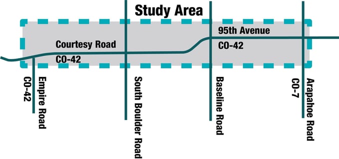
While serving as Project Manager for Future 42: Connecting People and Places, Pratt demonstrated how drones and aerial image data can save time and money on early-stage design projects. The Future 42 corridor study centered around providing the authorities and residents of Lafayette, Colorado and Louisville, Colorado with a conceptual design for physical improvements and community-focused enhancements along a 3 mile stretch of State Highway 42 (also known as 95th Street, CO042, or Courtesy Road).
The study involved three phases:
-
Understanding the site and community needs by gathering data and input
-
Analyzing the information to develop a collective vision and create design alternatives
-
Creating a final conceptual design, highlighting the top benefits and potential challenges
Although corridor studies are generally conceptual in nature and don't require the full survey-grade accuracy that is needed for a final construction design project, the initial information-gathering phase still entails a great deal of surveying and data collection. For Future 42, in order to understand the site and create a comprehensive final conceptual design, the required information included a topographical survey, ROW/ownership mapping, utility mapping, traffic data collections, floodplain/ floodway assessment, and an environmental overview.
Challenge
Shortly after winning the bid, Pratt approached Future 42 Lead Designer, Jeremy Jaeger, with a client concern: although the cities understood the need for a large amount of data, was there anything the team could do to reduce the $120,000 surveying fee for this conceptual design?
Jaeger immediately began researching various aerial imaging options as potential cost-effective alternatives to traditional surveying and drafting methods.
“We decided to look into photogrammetry for understanding terrain layouts and then what we could do in terms of building linework so that we could get this into CAD at a reasonable price without having to wait on surveyors and field crews," said Jaeger.
Jaeger considered several options, including 1) developing linework based on DEM's and 2) acquiring their own drone imagery and processing it in-house. However, DEM aerial imagery did not have the pixel resolution required for some of their deliverables. Additionally, Jaeger determined that using an in-house team to develop linework and topography from drone images would not be the most cost-efficient solution. The CAD work would fall on already-overloaded junior-level staff and end up consuming valuable employee time that could be better spent on other portions of the project.
Solution
That’s when Jaeger realized this might be the perfect project to incorporate AirWorks’ automated drafting solution. Jaeger was familiar with AirWorks’s software; however, Future 42 would be on a much larger scale than any of Kimley-Horn and Airworks’ previous collaborations. Still, he wondered if large-scale implementation might also mean large-scale savings. After crunching the numbers, he realized that AirWorks’ AI-powered data processing and autonomous drafting were the innovative means he needed to help reduce costs and free up staff.
"When comparing the cost of what it would take for us to provide CAD support versus working with AirWorks, there was a significant cost saving," explained Pratt.
As it turns out, replacing traditional survey work with drone data and automated feature extraction, linework, and topography developed with AirWorks’ AI software cut $60,000 off the initial fee - a 50% savings.
![]()
Additional Benefits
Pratt and Jaeger agree that the AirWorks app was overall easy to use and highly convenient. By using the templates feature, they were able to upload their own CAD standards, meaning final deliverables would come back with linework and style consistent with company standards. Additionally, the team found importing KML files to the app to be a simple process, and they appreciated the ability to submit multiple KML files within the same project. In lieu of spending valuable project hours drafting, the team could simply upload their drone files to AirWorks and receive ready-to-go deliverables created with the help of AI and reviewed by one of AirWorks’ quality assurance civil engineers – all in a fraction of traditional turn-around time.
However, one of the main benefits of using AirWorks was still to come. Incorporating AirWorks’ automated drafting services into the project workflow meant that the team had the availability and resources to help out their client by taking on some unexpected work.
According to Pratt, about a month into the Future 42 project, the town of Louisville approached Kimley-Horn about moving forward on conceptual designs for a series of underpass projects. The projects needed to be expedited in order to meet a deadline for a ballot measure just a few months away.
"The key thing was we needed to mobilize quickly to get data because we needed to do a conceptual design of five underpasses in two months," said Pratt.
The team already had AirWorks’ linework from the Future 42 project that they could use for two of the underpasses. Additionally, based on their Future 42 experiences, they were confident they could quickly gather the additional underpass information and turn out high-quality deliverables through their partnerships with their drone vendor and AirWorks.
"Having just gone through and discussed with AirWorks and our drones, it was a no-brainer for us to keep doing that."
Looking Forward
Currently, Jaeger believes photogrammetry brings the most value to conceptual design projects. A simple drone scan can provide a comprehensive baseline overview of existing conditions much more quickly and easily than traditional land surveying. Meanwhile, Pratt hopes to expand Kimley-Horn’s use of drones and photogrammetry to final design phases, especially as drone data accuracy and general awareness and acceptance of the technology increases.
Either way, the cost and time-saving potential of drone technology and associated AI drafting software is undeniable. Pratt credits one of his fellow project managers with recognizing how far this technology has come:
“Finally, our technology has caught up to where we can start saving more on projects versus it costing more to use technology.”
To learn more, visit our website at https://airworks.io/.